Current Exhibitions
Oblique Views: Archaeology, Photography, and Time
Oct 25, 2015 — May 7, 2017
For the first time in Oblique Views: Archaeology, Photography, and Time, large prints of Heisey’s stunning images will be paired directly with the Lindberghs’. The exhibition opens October 25, 2015 and runs through May 7, 2017 at the Museum of Indian Arts and Culture.
During 2007 and 2008, flying at alarmingly low altitudes and slow speeds, Adriel Heisey leaned out the door of his light plane, and holding his camera with both hands, re-photographed some of the Southwest’s most significant archaeological sites that Charles Lindbergh and his new bride Anne photographed in 1929.
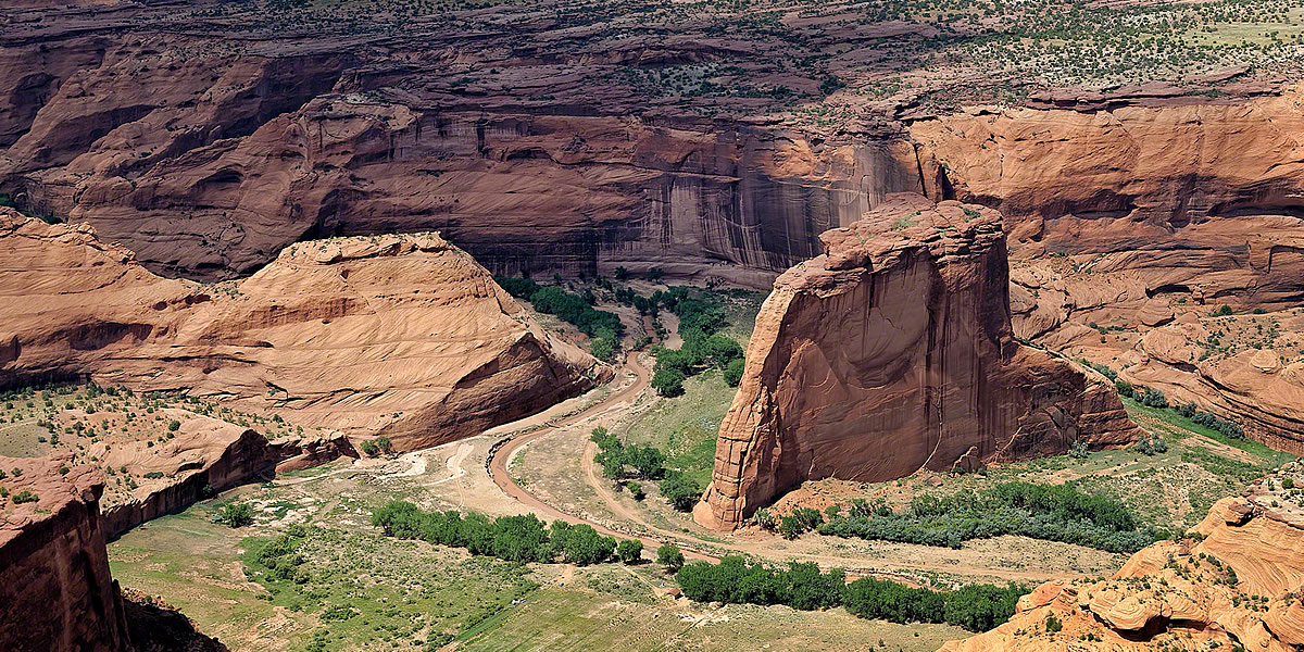
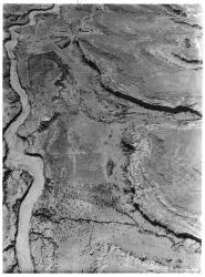
Pueblo del Arroyo, Pueblo Bonito, and Chetro Ketl
The minimal shadows cast by cliffs and walls in this photograph show that it, like its matching Lindbergh image of three great houses—Pueblo del Arroyo, Pueblo Bonito, and Chetro Ketl—was taken sometime close to solar noon. Although it’s high summer in a national park, human activity is low, perhaps because of the heat. A few cars are parked or being driven on roads, but the historic buildings, the ongoing archaeological fieldwork, and the ranching infrastructure that made the 1929 photograph so lively are missing. The park service made a conscious decision to remove historic structures, believing that they distracted from the more ancient Chaco period structures and features that the park was established to protect. Park service roads, parking lots, and trails both guide and constrain the visitor experience, and the landscape now appears comparatively barren. Photograph by Adriel Heisey, 2008.
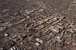
Santa Fe
While still not large, Santa Fe has grown remarkably since 1929. Houses cover the areas that were once farmed, and flat roofs around the Plaza dominate the scene. The Palace of the Governors (now backed by the New Mexico History Museum), the New Mexico Museum of Art, the cathedral, and other beloved buildings are still in use. The Roundhouse has replaced the old capitol building, which was remodeled and converted to administrative use. The river still flows through Santa Fe, at least seasonally, but it is less visible among the sea of buildings that engulf it. A few solar panels show environmental investment by individuals. Photograph by Adriel Heisey, 2015.
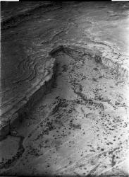
Pueblo del Arroyo, Pueblo Bonito, and Chetro Ketl
This higher-elevation photograph shows three great houses—Pueblo del Arroyo, Pueblo Bonito, and Chetro Ketl—in addition to what appears to be irrigated areas. The geographic proximity of these three great houses is clear. These and Pueblo Alto, on the upper bench to the right of Pueblo Bonito and not visible in this photograph, create what some have called Downtown Chaco. Historic use of the canyon can be seen in structures near Pueblo del Arroyo and Pueblo Bonito: buildings, a corral, and roads. Additionally, active excavation was taking place at Chetro Ketl when the photo was taken. Rather than being far from the bustle of the world, those living at Chaco Canyon in the summer of 1929 must have found themselves in a lively social setting. Photograph by Charles A. and Anne Morrow Lindbergh, 1929.
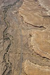
Pueblo del Arroyo
Pueblo del Arroyo lies immediately next to Chaco Wash, and its location inspired its name. When the Lindberghs photographed the site, the circular tri-walled structure on the western extension of the pueblo was being eroded by the wash. Neil Judd excavated a large part of the pueblo in the late 1920s, resulting in the empty rooms visible in both photos. The more modern buildings to the southeast of the ancient pueblo were built by Richard Wetherill in 1899 and served as a boarding house for archaeologists and other visitors. They were converted into the Chaco Canyon Trading Post in the 1930s. The road to Gallup crossed the wash nearby. Photograph by Charles A. and Anne Morrow Lindbergh, 1929.